


Le Casset, boucle botanique

lebretonjd
User
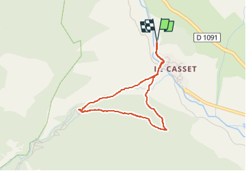

Length
3.4 km

Max alt
1641 m

Uphill gradient
122 m
Km-Effort
5.1 km

Min alt
1519 m

Downhill gradient
122 m
Boucle
Yes
Creation date :
2025-07-16 12:17:05.221
Updated on :
2025-07-16 13:51:36.215
2h15
Difficulty : Easy

FREE GPS app for hiking
 SityTrail
IGN / Geographical institutes
SityTrail Plus
The world is yours!
About
Trail Walking of 3.4 km to be discovered at Provence-Alpes-Côte d'Azur, Hautes-Alpes, Le Monêtier-les-Bains. This trail is proposed by lebretonjd.
Photos


51 photos in total. Please click on a photo to see them all in the gallery.
Positioning
Country:
France
Region :
Provence-Alpes-Côte d'Azur
Department/Province :
Hautes-Alpes
Municipality :
Le Monêtier-les-Bains
Location:
Unknown
Start:(Dec)
Start:(UTM)
301394 ; 4984886 (32T) N.
Comments